Cartographie 2 0
gps imagerie satellite serveur de
données géographiques applications de
localisation sur téléphone mobile
en fait l'informatique et les télécoms
ont complètement transformé les
technologies cartographique en plus on
observe la place grandissante
qu'occupent les contributeurs
volontaires pour accéder à ces savoirs
géographique et bien c'est ça qui m'a
intéressé et que je voudrais aujourd'hui
illustré par quelques exemples pour
commencer regardons ce schéma voici un
segment de territoire que nous allons
traduire en information géographique les
principaux éléments de cette pro graphie
sont modélisés par des formes
géométriques simples par exemple et
parcelles les espaces bâtis sont
représentés par des polygones les routes
par des lignes
enfin l'arrêt de bus est représenté par
un point toutes ses formes géométriques
sont géolocalisés c'est à dire qu'à
chaque point qui les composent
correspond une coordonnées géographiques
par exemple la latitude la longitude on
peut par ailleurs associé à ses yeux
mettrie d'autres informations comme le
nom des rues le type pour les bâtiments
ou encore lignes de bus desservant un
arrêt ainsi modélisés et renseigner les
éléments qui composent ce territoire
sont enregistrées dans des bases de
données informatiques et bien c'est la
matière première des cartes du 21e
siècle
alors comment procède-t-on pour saisir
les coordonnées géographiques de tous
ces éléments et bien soit en effectuant
des relevés terrain ce qui est somme
toute classique en cartographie soit par
photo interprétation c'est à dire en se
référant à des images vues du ciel ou de
l'espace car il y a eu la conquête
spatiale c'est la première révolution
dès 1972 elle permet à l'humanité de
découvrir des images de la planète bleue
la nasa et le western odjick on se
réveille lance le premier programme
américain d'observation de la surface de
là
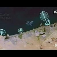
terre landsat précis par exemple une vue
de dubaï prises dans les années 70 et
puis en la comparant maintenant avec une
vue satellitaire de 2012 outre
l'expansion considérable de la ville on
peut noter des tenants projet d'îles
artificielles comme l'atoll de word au
fond par ces projets c'est un petit peu
comme si l'homme cherchait à être vus
depuis l'espace deuxième révolution en
1983 c'est l'arrivée sur le marché du
système américain le gps le global
positionning system fonctionnant à
partir d'un réseau de satellites
aujourd'hui au coeur des systèmes de
navigation embarquée taylor des
compagnies privées développe dans un but
commercial
des bases de données routières de grande
précision et ils ont l'ambition de
réaliser une couverture mondiale à
destination du grand public mais
l'élaboration et la mise à jour des
cartes topographiques officiel demeure
néanmoins la mission d'institutions
publiques professionnels aux états unis
les cartes us geological survey
en france celle de l'hygiène au japon
celle de la géospatiales une formation
de nos forêts étaient bien alors nous
allons voir maintenant comment internet
en facilitant les échanges de données
géographiques numériques a permis
l'émergence de nouveaux acteurs
au tournant du 21e siècle on estime qu
environ 20 % des requêtes sur les
moteurs de recherche portent sur des
lieux ou des adresses donc le marché est
considérable
c'est pourquoi les américains ils yahoo
aol microsoft google
le finlandais nokia le chinois baidu ont
chacun développé un portail
cartographique en ligne gratuits mis à
jour en temps réel sur le portail d'un
ol par exemple il s'agit de manipuler
des bases de données cartographiques
mondiale à travers une interface simple
de manière dynamique et interactive
l'internaute de connaître l'état du
trafic en direct
il peut rechercher des services de
proximité ou calculer un itinéraire
eh bien ces services sont une bonne
illustration de ce qu'on appelle le web
mapping
dans ce panorama google s'impose
rapidement comme leader aidé par son
moteur de recherche
conjointement au lancement de son
portail google maps la société
californienne propose de télécharger
gratuitement google earth une
application qui permet la visualisation
en trois dimensions de données
géographiques notamment des images
satellites et aérienne alors pour cela
google acquiert des droits de diffusion
auprès de multi agences spatiales et
cartographiques par exemple la nasa ou
l'hygiène pour le territoire français
pour donner plus de réalisme encore à ce
globe virtuel google propose à partir de
2006 d'afficher des bâtiments en trois
dimensions dont google à l'idée alors de
faire appel aux contributions des
internautes
chacun peut ainsi proposer d'ajouter des
bâtiments qu'il modélisent lui-même
qu'il s'agisse de sa propre maison ou
d'un monument célèbre c'est ce qu'on
appelle le crowdsourcing c'est à dire
utiliser les internautes pour créer du
contenu pour l'anecdote c'est tour
eiffel qui est visible actuellement dans
google earth est l'oeuvre d'un interne
au britannique passionnés et non pas
d'une source officielle
cette démarche participative est à
l'origine d'un autre projet de
cartographie numérique lui aussi lancé
en 2005 et qui s'appelle openstreetmap
en abrégé au sm dont vous voyez ici le
logo alors comment est ce que ça
fonctionne chaque contributeurs
bénévoles professionnels ou amateurs
ajoute ses propres d'information en
s'appuyant par exemple sur des images
satellite ou aériennes qu'elles soient
publiques ou mises à disposition par des
partenaires privés
d'autres formes de partenariats existent
comme par exemple aux états unis ou au
sm a pu importer pour l'état de géorgie
les données d'occupation des sols grâce
à la contribution des services fédéraux
de l'ue sgs regardez cette animation qui
retrace comment des contributeurs de sm
ont progressivement cartographier berlin
entre 2005 et 2010 alors vous voyez où
sm est une vraie communauté de
cartographes
elle crée et met à jour une base de
données mondiale de grande précision
multilingue entièrement libres de droits
sur le modèle de wikipedia en 2012 la
commune
théo sm compte environ 600 mille membres
inscrits à travers le monde
mais en moyenne seuls vingt mille
membres contribuent de manière active
chaque mois voici maintenant un site qui
s'appuie sur openstreetmap vous voyez
ici le quartier de 8h à berlin où les
internautes ont localisé des boutiques
des restaurants des lieux publics qui
peuvent être soit non accessibles
partiellement accessible ou totalement
accessible aux personnes en fauteuil
roulant l'ampleur sur le web du
phénomène collaboratif a finit
évidemment par intéresser la plupart des
acteurs professionnels de la
cartographie en 2008 google lance google
map maker un nouveau service pour une
mise à jour participative de ces données
cartographiques
vous pouvez voir sur ce site les
contributions quasi en temps réel
d'internautes du monde entier
vous voyez se dessiner un tracé des
tauriel dans le bas de l'image
il s'agit en effet de la collaboration
d'un internaute qui a ajouté les pistes
d'un aéroport au surinam en haut le
visuel nous emmène dans une autre région
du monde
ici par exemple on indique une localité
au jammu et cachemire en inde
ici il s'agit d'une école en serbie ici
on a un bâtiment universitaire au texas
là on a une zone d'habitation en algérie
ici encore le tracé d'un chemin au
pakistan notons que la quasi totalité
des grandes villes pakistanaises ont été
cartographiées par des contributeurs
bénévoles
alors qu'elle sera demain la carte de
référence sur le web
ainsi pour les grandes villes comme
paris google maps et open street map
affiche des données extrêmement détaillé
ni l'un ni l'autre ne propose encore une
couverture complète et homogène du monde
regardez maintenant la place de la
république en travaux en 2012 à paris
sur google maps en eau les modifications
de circulation ne sont pas prises en
compte alors que les contributeurs de sm
ont été particulièrement réactif et bien
de manière plus générale les emplois de
ce qu'on appelle le web mapping son
multi
très divers et de plus en plus utilisé
par le public voudrais m'arrêter
maintenant pour finir sur un usage
spécifique du web mapping aux situations
de crise humanitaire à travers l'exemple
d'haïti le 12 janvier 2010 un
tremblement de terre de magnitude 7
frappe le pays et notamment la capitale
port au prince plusieurs agences
spatiales pointent alors leurs
satellites sur le pays et en quelques
heures des nouvelles images de la ville
sont mises en ligne et en libre accès
plusieurs portails dédiés sont aussitôt
mis en place sur le web pour centraliser
et partager un maximum d'informations
celui de google est mis en ligne dès le
lendemain de la catastrophe
on voit ici la localisation des
principaux immeubles endommagés au
lendemain du séisme et des premiers
camps de sinistrés
repéré par des internautes bénévoles
grâce aux premières images satellites la
communauté au sm se mobilisent aussi
très rapidement alors qu'elle n'avait
jusqu'à lors que très peu cartographier
et port au prince elle réussi à dresser
en seulement deux jours un plan détaillé
et structurée de la ville à partir des
images aériennes et satellites prises
après le séisme
ces données étant libres de droits elle
profite à l'ensemble des acteurs sur le
terrain notamment aux ong et aussi et
c'est là que c'est plus intéressant à la
banque mondiale et aux agences
onusiennes qui les complète à leur tour
et elle continue aujourd'hui à être mise
à jour et à servir de référence pour la
phase de reconstruction du pays
alors il est difficile de savoir si les
efforts de quelques cartographe
bénévoles vont suffire à maintenir cette
carte à jour et opérationnels et dans le
cas de haïti au sm a tout de même été
capable de pallier l'absence de
structure de cet état en mettant à
disposition un outil cartographique
collaboratif est totalement gratuit
alors qu'elle va être à l'avenir le
support cartographique de référence sur
le web c'est la question que l'on se
pose dans le domaine d'activité compte
tenu de
l'enjeu commercial industriel culturel
et politique
alors ça n'a rien de nouveau dans
l'histoire de la cartographie mais ce
qui est nouveau c'est comment va-t-on
garantir la protection des données
visualisables qu'elles soient
personnelles ou institutionnels et là ce
n'est pas tout à fait claire alors si
vous voulez revoir certaines de ces
images qui sont étonnantes ou bien
consultez vous même les sites et les
services que nous avons évoqué dans ce
dessous des cartes
je vous renvoie au site arte.tv